From 1972 to 2005, Finland’s base maps were based on the National Mapping Coordinate System (Kartastokoordinaattijärjestelmä, KKJ), which divided Finland into six projection zones (KKJ0, KKJ1, KKJ2, KKJ3, KKJ4, and KKJ5). The central meridians of these projection zones are at 18°, 21°, 24°, 27°, 30°, and 33° east longitude. The Uniform Coordinate System (Yhtenäiskoordinaatisto, YKJ) represents all of Finland in a single plane coordinate system by extending the KKJ3 projection zone eastward and westward.
In the Uniform Coordinate System, north and east coordinates (abbreviated as P and I) are used. The north coordinate expresses the distance in meters north of the equator, with values ranging from 6,600,000 to 7,800,000 meters within Finland. The east coordinate’s value for the 27° central meridian is set at 3,500,000 meters to avoid negative values. Within Finland, the east coordinate values range from 3,000,000 to 3,800,000 meters.
Abbreviations such as Grid27E or KKJ3 are also used for the Uniform Coordinate System. The EPSG identifier for the Uniform Coordinate System is EPSG:2393.
Use of Uniform Coordinate System in Biological Surveys
The Uniform Coordinate System has been used in biological observation data since the 1970s. Based on the YKJ coordinate system, Finland has been divided into square sub-areas, the size of which is determined by research needs. The most commonly used division in national biological surveys is based on the 10 km x 10 km YKJ grid squares. There are also divisions based on 1 km x 1 km and 100 m x 100 m YKJ grids.
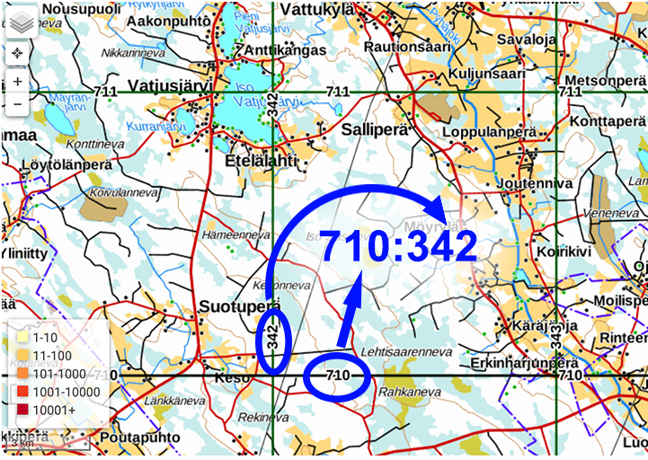
In biological data, the location and size of a YKJ grid square are simultaneously expressed with a series of numbers, starting with the north (P) coordinate, followed by a colon, and then the east (I) coordinate (e.g., 682:332). The length of the series indicates the size of the square. Coordinates for a 10 km x 10 km square have 3+3 numbers (e.g., 682:332), for a 1 km x 1 km square 4+4 numbers (e.g., 6825:3324), for a 100 m x 100 m square 5+5 numbers (e.g., 68257:33246), etc. The P and I parts of the coordinates are always the same length, and the first number of the I part is always 3 in Finland.
The southwest corner (bottom left) P coordinate of a square is obtained by adding enough zeros to the end of the P coordinate to make it a seven-digit number. The I coordinate is similarly extended. For example, the southwest corner coordinates of the square 682:332 are P = 6820000 and I = 3320000.
The northeast corner (top right) location is obtained by increasing the P and I coordinates by one and adding enough zeros to the end to form a seven-digit number. For example, the northeast corner coordinates of the square 682:332 are P = 6830000 and I = 3330000.
Since 2005, new topographic maps have been depicted in the ETRS-TM35FIN plane coordinate system, which, like the YKJ coordinate system, covers the entire area of Finland. However, ETRS-TM35FIN coordinates are not identical to YKJ coordinates. Puupponen (2008) has described conversion formulas that allow converting YKJ coordinates to ETRS-TM35FIN coordinates with an accuracy of about one meter, which is usually sufficient for biological data.
Coordinate grids used in biological surveys are depicted in the ERTS-TM35FIN coordinate system, with the corner points of each square presented with meter accuracy in the ETRS-TM35FIN coordinate system. Abbreviations used in the YKJ coordinate system (e.g., 682:332) can be used as names for these squares.
The corners of grids depicted in the ETRS-TM35FIN coordinate system can also be accurately converted to the globally used WGS84 coordinate system, which is commonly used in GPS devices.
Map Usage Instructions
The background maps of the Finnish Biodiversity Information Facility’s map service are digital background maps from the National Land Survey of Finland. You can move and zoom the map using the mouse. By holding down the shift key, you can draw a rectangle on the map with the mouse, which will zoom in on the selected area.
You can display the layer “YKJ Grid” on the map, which shows the boundary lines of the uniform coordinate grid at different scales. As a separate layer “YKJ Labels”, you can display the series of P and I coordinates. The coordinates of a grid square are obtained by taking the P coordinate from the bottom edge and the I coordinate from the left edge of the square.
On the right side of the map, there are drawing tools that allow you to draw points, lines, and polygons on the map. The buttons on the right also allow you to output the coordinates of the drawn shapes in three different text formats and three different coordinate systems. You can also import shapes defined in the same formats and coordinate systems onto the map.
Uniform Coordinate System (YKJ) as Geographic Information Data
The 10km and 1km grids of the uniform coordinate system are available for download as geographic information data (shp) in the ETRS89-TM35FIN and WGS84 coordinate systems in the following formats:
| Name | File Format | CRS | Description |
|---|---|---|---|
| YKJ10km_gridlines | shapefile | ETRS89-TM35FIN | The dataset includes the grid formed by the vertical and horizontal lines (E, N) of the YKJ10 along with identifiers |
| YKJ10km_polygons | shapefile | ETRS89-TM35FIN | Polygon data formed from the YKJ 10km grids |
| YKJ10km_polygons _WGS84 | shapefile | WGS84 | Polygon data formed from the YKJ 10km grids |
| YKJ1km_polygons | shapefile | ETRS89-TM35FIN | Polygon data formed from the YKJ 1km grids |
| YKJ1km_polygons _WGS84 | shapefile | WGS84 | Polygon data formed from the YKJ 1km grids |
This data is open data produced by the Finnish Biodiversity Information Facility (FinBIF) (CC BY 4.0).
References
- Heikinheimo, O. & Raatikainen, M. 1971: Paikan ilmoittaminen Suomesta talletetuissa biologisissa aineistoissa. — Annales Entomologici Fennici 37: 1–27, liitt.
- Heikinheimo, O. & Raatikainen, M. 1981: Ruutukoordinaattien ja paikannimien käyttö Suomessa. (Grid references and names of localities in the recording of biological finds in Finland). — Notulae Entomologicae 61: 133-154.
- Puupponen, J. 2008: Tunnetko koordinaattimuunnokset? — Positio 1/2008: 27-29.